Dec 25, 2012

2012-13 Cycle: 500mb Map Loops

The Northern Hemisphere 500mb map compare for the 2012-13 cycle has begun at the OSNW3|WxClimate website. Click on the image, then use the drop down selection and select "2012-13 Loops" to check them out.


"The loops are a tool to capture and correlate the flow of the entire Northern Hemisphere from cycle to cycle. Each individual cycle is dated and determined by the average cycle length. Each loop is manually animated in either direction by clicking on the arrow buttons. Each day in a cycle is numbered. Use the calendar to easily find and compare specific dates."
.

Dec 1, 2012

But What Is It Good For?

"I confess that in 1901, I said to my brother Orville that man would not fly for fifty years... Ever since, I have distrusted myself and avoided all predictions." -- Wilbur Wright, 1908

After a few muses from @kcwxguy I found myself knee deep fiddling with Google Visualization. It soon became a fresh way to visualize my forecast model data based on LRC theory. The winter of 2012-13 begins my third year following the cycling weather patterns of the northern hemisphere. An eagerness to learn has grown into a passion. From a once inconceivable backyard snowfall forecast in 2010, to a winter outlook for Oshkosh in 2011, to seasonal forecast numbers for the entire Midwest in 2012-13. The idea has certainly grown on me.

As we get "pattern change" shoved down our throats the next two weeks I want to reiterate the fact that this "pattern change" is not something new to the eyeballs that have been following the cycling patterns of 2012-13. The particular pattern has been projected for months. It is evident in all of the trends for the cities that will be affected. I will focus on temperatures. Below is a screenshot animation from the OSNW3|WxClimate site of a Google Geo Chart depicting the maximum temperature deviation for the Midwest cities selected for trends this season. There are three images in the animation. An image for Dec 1-14, Dec 15-28 and Dec 29-31. Clicking on the image will take you to the maps website for a larger view.


What isn't on the media radar yet, well at least I haven't seen it, is the extreme warm-up that could take place in the Midwest the last few days of 2012. Below is another screen capture of the OSNW3|WxClimate site. This Google Motion Chart is showing all of the cities max temperature departures from average for the month of December. By following the thick blue line it is evident something warm will be recurring near the end of the year. The same idea is shown above in the third frame of the animation.


(From the Event Mapping page click on "Motion Chart" to use the chart yourself)

We all know a weather prediction made one month out is seldom followed through to fruition. Most of us will not trust a computer generated forecast more than 3 days out. A major asset of the theory, in my opinion, is it's ability to predict significant "pattern change". Give or take a day, I am confident this will all take place, even before the populous had hints from long range computer models.

If there are any questions or thoughts on my research and analysis of the LRC or how I presented the material just let me know in the comments section of the blog. Thanks for reading!

Nov 16, 2012

Actively Seeking A Cycle Length

On Nov-4 I posted about a seasonal twist. The outcome of the so-called twist led me down a path of a new and extended cycle duration leaving an unanswered question as to why. I passed on the attempt to answer the question. Instead I followed this new cycle duration for another 10 ish days until the patterns yet again switched on me. Or did they? The cycle duration flux is documented in the comments of the linked entry above. To make a long story short, time has pushed forth and the map comparison below is where I am at in the cycle as of this posting. I will call it "55-ish" days.

(Sep-29)


(Nov-25 | 18Z GFS Nov-16)


----

For the past year I've been working on a way to utilize the knowledge of cycling weather patterns. While I know there will be better ways to present the massive amounts of data in future renditions, with potential future partners, I decided I needed to pull the trigger with what I had built to see how it would perform in a real time environment. The host website will likely always be "under construction" but under most circumstances will always be in production. I invite everyone reading to gander at what I think our cycling weather patterns have to offer for weather and climate forecasting.


Click on the screen shot to navigate to the trends. I welcome all feedback on the site, the data, the 'model' output... anything, as it will help me improve/disregard the product in the future.

If there are any questions or thoughts on my research and analysis of the LRC or how I presented the material just let me know in the comments section of the blog. Thanks for reading!

Nov 4, 2012

Seasonal Twists Abound?

I sense a pucker factor emerging in map correlations with the current flow of the middle atmosphere using the early derivation of the 2012-13 cycle length. All is good though, rolling into what the GFS is putting out for late week. The ULL off of the west coast is in the flow this cycle providing an eye popping difference between map comparisons...

(Sep 18-19 and GFS Nov 7-8)


This comparison is in the low 50s of cycle length that I've been following along with since mid August.

Moving forward (GFS Nov-11) this may not be something we've seen in the maps yet but is certainly apart of the 2012-13 cycle. Is it a seasonal twist in the jet just more evident due to the ability of finding the cycle earlier? Or just the simple fact that patterns in the cycle have not yet been established and we're still waiting for them to evolve as the core theory states? What do you believe?

This is a great time for critics to come out of the woods and express their discontent with compounding theories on the core theory or even better with the theory in general. No matter, it is all good fun. Patience is a virtue.

If there are any questions or thoughts on my research and analysis of the LRC or how I presented the material just let me know in the comments section of the blog. Thanks for reading!

Oct 28, 2012

Intangible Arguments Within The 2012-13 Cycle

Hurricane Sandy.

It is unlikely that the moisture from Sandy will be a recurring feature in this years cycle. It is a tropical entity and while another ULL may form again in other cycles, the genesis placement, path, and strength will most certainly differ as the Jet steadily marches south.

But first. As I understand, the cycle breathes, the duration of the cycle oscillates inside a 1-2 day window on either side. My last map to map correlation had a duration of around 53 days. Reanalyzing, now that the end date (Oct-23) is real and not a forecast model, I now see something just a little different. 51 days.

(Sep-5, 2012)


(Oct-25, 2012)


The map comparison above and the image combining them below show Low's in similar position. More info on the ULL off of Florida from early September click here. And, obviously Hurricane #Sandy.

(Sep-5 and Oct-25)


If there are any questions or thoughts on my research and analysis of the LRC or how I presented the material just let me know in the comments section of the blog. Thanks for reading!

Oct 18, 2012

The 2012-13 Cycle - From The OSNW3 Perspective

Finding the "transition" cycle was not easy. It took me over two years to even grasp the thought. The late summer and early fall of 2012 has been a break through season. I have to give credit to Doug Heady and Scott Metsker for assisting me in finding it. It truly does exist. The old 3/4-ish harmonic, below. (32 days)

(Sep-14)


(Oct-15)


Take a moment to follow this pattern back/forth through time (click on the images they will open a new tab). It can be a good lesson on how seasonal "twists" evolve. While this is the overly mentioned and often misinterpreted "stare and compare" method of viewing the correlations, to me it is still the preferred method. Unmolested data.

With hints from other theorists, I have been able to personally discover that it is possible to find the new cycle one to two months prior to the core theory, Gary Lezak, rule of October and November. While some will argue, I maintain my stance and make the effort in providing visual proof. Take the maps below for an example (50-ish days)...

(Aug-13)


(Oct-1)


Click on the images (they will open a new tab) and move the maps forward in time. A pattern exists six consecutive days until a seasonal twist interrupts the flow in the August pattern. After all, it was August and the waning anti-cyclone of summer was prevalent. Now, take the comparison below (53-ish days), here we are again seeing the same patterns of late summer and early autumn.

(Sep-1, 2012)


(Oct-23, 2012)


I am 99.9% confident that we have met the patterns that will be the cycle of 2012-13. Allowing the patterns to evolve with the season (patience) will harbor a definite and accurate long range forecast probability.

If there are any questions or thoughts on my research and analysis of the LRC or how I presented the material just let me know in the comments section of the blog. Thanks for reading!

Oct 1, 2012

Thoughts On Upcoming Patterns

Could this be a sign of new patterns in a new cycle? A 50-51 cycle duration? I find analyzing 500mb maps is a fun pastime. The old 'stare and compare' method.

Aug-18 correlates to the GFS Oct-6
Aug-25 correlates to the GFS Oct-14


I've been following a couple cycles as of late. The 2011-12 46-ish day cycle has had a few last gasps and I picked up on a 40 ish day cycle that quickly shrunk down to 30 ish day cycle (see Aug-18 and Sep-21 and go backwards for an example) that I am losing confidence in, but now...

Sep-7 correlates to the GFS Oct-6, it grows a day or two...
Sep-12 correlates to the GFS Oct-15


----
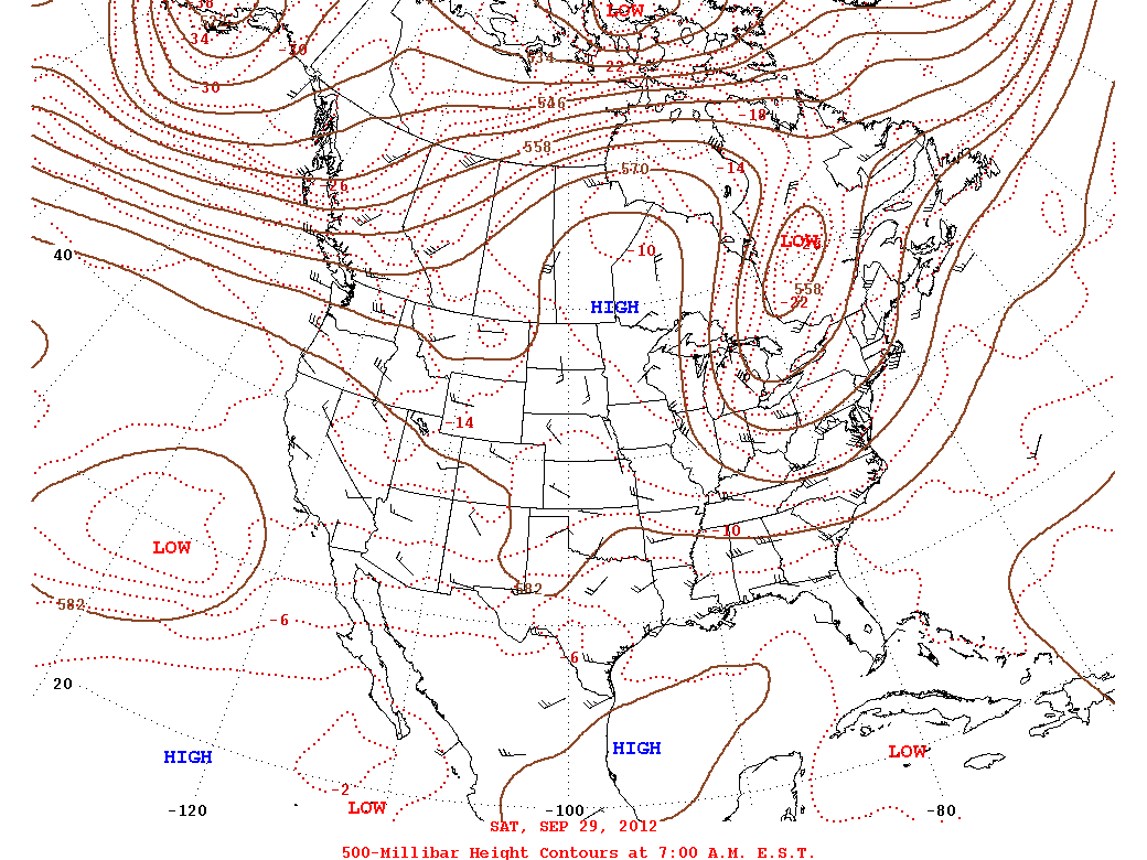
(first posted on Sep-24, 2012)

Cycle length is still shrinking. New energy is being added to the patterns.

(Aug-30)


(GFS Oct-3: 204hr Forecast Sep-24)


I love me some map to map comparisons. Knowing the LR models are usually a day or two early, put this comparison in motion and it would seem the GFS has the right idea with a near 40 day cycle length.

----
(first posted on Sep-10, 2012)


There has been activity in the Bearing Sea and Gulf Of Alaska lately that will soon resemble a unique pattern of this years LRC.

(Pacific 500 Analysis: Aug-29/Sep-9)


This particular pattern started to take form during the middle of September last year and then solidified itself a spot in the 2011-12 cycle the first half of November. Recurring the second half of December, first half of February, second half of March, first half of May, second half of June, first half of August, and now likely to recur one more time the second half of this September. (Follow this pattern through the seasons by utilizing the 2011-12 LRC Calender A linked date will bring up the 500 map for that day)


The 2011-12 cycle patterns are transitioning. Since middle August the duration of the cycle has seemed to slowly shrink. In other words the patterns are cycling through at a quicker pace and likely morphing as "new energy" is introduced with our strengthening jet stream. For example, the first half of August is showing a strong resemblance to the GFS 500 forecast beginning September 13. 40-ish day duration. Back to back to back eastern half of CONUS/CANADA troughs.

(Aug-4, 2012)


(GFS Sep-10: 075hr Forecast Sep-13)


It would seem there should be three or four consecutive troughs entering the eastern half of CONUS/CANADA during the second half of September which is a pattern that has been recurring since last November. Soon after this has taken place, confidence is high that 2012-12 cycle patterns will begin to reveal themselves with a more eye popping appeal. Game on?

If there are any questions or thoughts on my research and analysis of the LRC or how I presented the material just let me know in the comments section of the blog. Thanks for reading!

Aug 13, 2012

The 2011-12 Lezak's Recurring Cycle

Last month I tweeted that I was not sure this pattern would repeat again this year. The GFS is telling me I was right, I wasn't sure.  It's in the medium range forecast plot once again.  The overall cycle is still in charge but there are signs it is evolving!


(Aug-18, 2012 - GFS 126HR 8/13)


If this pattern repeat happens on Aug-18, I think we have started the morph where we'll begin to actually notice the stark differences. According to my calendar, this will be happening way too early.  I suppose I should be patient. This same thing happened back in May when the maps coincided early and the cycle held together. The GFS actually hints at that same thing happening as it did in May. A simple case of jumping the gun as I may be a little excited for a new pattern to evolve.

----
(first posted on Jul-16, 2012)

The summertime jet is full effect. This means the 2011-12 cycle will soon begin to morph into the 2012-13 cycle. I will admit I am very anxious for this transition to begin. But, before I become truly entrenched into the hunt I want to recall how I got into this mess to begin with. In honor of the 2011-12 cycle I will follow the 500mb plots through my calendar. Nov-17 was the first I saw the cycle go full circle.

(Sep-30, 2011)

(Nov-17, 2011) - 48 Days

(Jan-2, 2012) - 46 Days

(Feb-17, 2012) - 46 Days

(Apr-3, 2012) - 46 Days

(May-21, 2012) - 48 Days

(Jul-8, 2012) - 48 Days

----
(first posted on Nov-18, 2011)

I was waiting to update the blog until there was an archived 500mb plot to compare cycles. That opportunity came Nov-18. A comparison for the days of Sep-30 and Nov-17 provides a result of a 48 day cycle duration as of this writing. Moving each of the days back one day in time also yields similar setups. Moving forward, the patterns are cycling. It is noticeable with this initial comparison how the strengthening and south ward march of the jet stream affects the cycle. It's time to get down and dirty with this years cycle and analyze the ever changing seasons as they bring with them their own unique twist. On a side note, as the season moves into winter the cycle duration will likely extend a few days and even more importantly, there is no more need for living in fantasy land to find the cycle! (fantasy land = long range computer models)

----
(first posted on Dec-30, 2011)

Much of my research has led me to the conclusion that the patterns within a particular cycle take on a more similar look and feel to the, 'every other' or non consecutive cycle rather than the one preceding or following that particular cycle. For example, cycle 1 & 3 & 5 are more similar to each other while cycle 2 & 4 & 6 are more similar to each other. The 'birthday' of the 2011-12 LRC is a great example and should be considered a signature feature. This time around the surface features and 500mb flow are shaping up very similar to Sep-30.

----
(first posted on Feb-21, 2011)

I was very much looking forward to this 'birthday' of sorts for this years LRC. It was scheduled to take place while we were to spend time in Marquette, MI. Realizing what the potential was excited us as we were in store for snow and waves if it were to act like the Sep or Jan version. However, what happened was more like the Nov version. We were still greeted with a little bit of snow and waves, but without the intensity we wished for. The conclusion I stated below has proven itself this time around, will it next time? Could another trip to Door County, WI for some big wave action be in store? Only time will tell. Happy birthday LRC. The 500mb map has been added below for comparison.

----

If there are any questions or thoughts on my research and analysis of the LRC or how I presented the material just let me know in the comments section of the blog. The 2011-12 LRC calendar can be found here and is also accessible from the LRC Analysis Tools section in the upper right portion of the blog. Thanks for reading!

Aug 4, 2012

The Current Pattern's Life Throughout The 2011-12 Cycle

I dedicated a small chunk of time tracking our current pattern back through the seasons. It was an interesting ride. The most obvious conclusion, leading up to this comparison, is we are still holding onto the overall 2011-12 cycle, but significant, while yet very small, changes are taking place. However, the recent and current instability has occurred before. This is the same pattern that brought the thunderous weather the first week of May when Oshkosh recorded 4+ inches of rainfall on May 2. Also the same pattern that riddled the area with thunderstorms the third week of June.

Anyway. Not for the lighthearted, but consider the Aug 3 500mb map.

(Aug 3, 2012)

Take this pattern back through each cycle to Oct 26, 2011.

2011-12 OSNW3 LRC Calendar
8/4, 6/19, 5/4, 3/18, 1/31, 12/14, 10/26 - give or take a day.

(Jun 19, 2012) - 46

(May 4, 2012) - 46

(Mar 18, 2012) - 47

(Jan 31, 2012) - 47

(Dec 14, 2011) - 48

(Oct 26, 2011) - 49

I searched for a September 2011 match beginning at 47 days from Oct 26. What I expected is to find a map not matching and that is exactly what I found. Going back and forth in time from that date I was able to see sporadic similarities to the 2011-12 cycle. See the morphing taking place? I was somewhat blown away. This theory never ceases to amaze me. Looking forward to the next two months!

If there are any questions or thoughts on my research and analysis of the LRC or how I presented the material just let me know in the comments section of the blog.

Jun 12, 2012

Another AccuWx 25 Day Forecast Comparison

This is my third installment of following the AccuWeather 25 day temperature forecast and comparing the output to my cycle temperature trend output. One and Two can be found by clicking on the links. In the second comparison last month I eliminated a portion of the cycle in hopes of quantifying the dynamics of the trend. Turns out one "anomaly" did the trick and the LRC came out on top with less error.

I create the comparisons by saving a snapshot of the AccuWx forecast and uploading a 'cached' version of the webpage onto my server where it sits unmolested. (I took the June snapshot on June 4th) I then extract the AccuWx data into the graph shown below. As the month progresses the graph will dynamically update after I enter in the observed daily temperatures. Check back every now and then to see the ongoing results.


(Click on the graph for the full set of data.)

If there is anything substantial to the 'every other cycle' thought process the second half of June should be a scorcher here in Oshkosh. The cycle comparisons used to generate the model trend output are my interpretations of the cycle. My interpretations of the cycle are lined out in my cycle calendar. If there are any questions or thoughts on my research and analysis of the LRC or how I presented the material just let me know in the comments section of the blog. Thanks for reading!

Jun 11, 2012

Every Other Cycle?!

Update: June 26, 2012

"If you look at this play what we're trying to get is a seal here, and a seal here, and we're gonna run this play in the alley" - Vince Lombardi

Two cycles ago. Mar 19, 2012.

And two cycles before that. Dec 14, 2011.

Did you see it coming?

Next week. Jun 18, 2012 (Jun 11 - 18Z GFS Forecast)

Turns out Jun 20, 2012 was the day. 
Good job GFS, just 2-ish days early...

Below are duration calculations to put the time frames into perspective.

Dec 14 to Mar 19 = 97 days / 2 cycles = 48.5 days
Dec 14 to Jun 18 = 188 days / 4 cycles = 47 days
*Mar-19 to Jun-18 = 92 days / 2 cycles = 46 days **
**As jdrenken has proven, the computer models are usually a day or two quick this far out. Click on his forum handle to learn more.

Mar-19 to Jun-20 = 94 days / 2 cycles = 47 days

As always, all these comparisons boil down to the beholders interpretation of the cycle and I can't emphasize this feeling enough. My interpretation of the cycle is lined out in my cycle calendar. If there are any questions or thoughts on my research and analysis of the LRC or how I presented the material just let me know in the comments section of the blog. Thanks for reading!

Jun 3, 2012

The Battle Continues

Seriously, how fun is this, comparing the AccuWx 25 day forecast to the LRC? At this point, who really cares right? I mean, it is what it is. The theory is going to have critics, the theory is going to have followers. Personally, I am past trying to convince people (myself) that our atmosphere cycles. This stuff has become a passion and I just simply enjoy following along.

Anyone who follows along, anyone who takes the time to understand the theories (yes, it is not cut and dry) knows it is a fantastic magical joy ride crystal ball and is crucial to have in a forecasting bag of tricks. You know exactly what I am talking about, the smoke and mirror gag and the delusional eye strain gag where a woman gets chopped in half.

It all boils down to the beholders interpretation and I can't emphasize this feeling enough. My interpretation is in my calendar. Other interpretations are located on the right hand side of this blog under the "LRC Blog Roll". Once this baby breaks out it will come down to who legitimately follows along and it will be noticeably evident in the accuracy and confidence of the forecast.

Within my model analytic I have these magical buttons that suppress certain portions of a cycle. I decided to run the model twice for this comparison. I enjoying playing with numbers.

AccuWx 25 day forecast May 6-30, 2012 versus the LRC.
(cached version of AccuWx forecast)


Click on the graphs for the entire data set. If you choose not to, I can just tell you that AccuWx won versus the blend of all cycles of the LRC. Not by much, but still. I couldn't let the LRC lose, so I got rid of the March data. Wallah! LRC kicking butt once again.

If there are any questions or thoughts on my research and analysis of the LRC or how I presented the material just let me know in the comments section of the blog. Thanks for reading!

May 13, 2012

Eastern WI - May 10, 1990 & the LRC

The latest snowstorm on record to affect our area took place on May 10, 1990. I was living in Suamico, WI at the time and remember it well. Obviously, these record conditions sparked my interest of following it through the cycle to analyze the behavior of our atmosphere that year.


Below is the archived map from May 10, 1990. Easy to see from the map that there was a potent low pressure centered in Lower MI streaming cooler air into WI helping to produce the snow that fell.


Analyzing the data and maps from 1989-90 I concluded the cycle averaged around 54 days. Starting with May 10, 1990 moving back through the year I ran into these dates.

Oct-10, 1989 - 19891009-19891015.djvu
Dec-02, 1989 - 19891127-19891203.djvu - 54 days
Jan-25, 1990 - 19900122-19900128.djvu - 55 days
Mar-19, 1990 - 19900319-19900325.djvu - 54 days
May-10, 1990 - 19900507-19900513.djvu - 53 days

By using the archived maps above I was able to pick out the storm in every cycle with ease. I would suspect this storm could have been labeled a 'signature storm' that season. It recurred on schedule in the Great Lakes each and every time. Simply amazing. See the image below. Right click, select open in new tab/window to see a larger version.


The image below is of a tree that fell onto our garage that day due to the weight of the heavy snow.

(Suamico, WI - May 10, 1990)

Besides that particular storm the late winter season of 1989-90 had an extreme warm-up on March 12, 1990 that melted snow quickly creating flood conditions. I suspect that is me in the flood waters and I am sure I was wearing knee high rubber boots in the photo below.

(Suamico, WI - March 12, 1990)

Sticking with the same duration of around 54 days I was able to pick the dates listed below when following this particular pattern through the cycle. I am questioning my January comparison as it wavers from the average a little bit, but with this comparison the average is around 53 days. It is darn close.

Oct-05 - 19891002-19891008.djvu
Nov-27 - 19891127-19891203.djvu - 53 days
Jan-17 - 19900115-19900121.djvu - 51 days
Mar-12 - 19900312-19900318.djvu - 54 days
May-04 - 19900430-19900506.djvu - 53 days

By using the archived maps above I was able to pick out the western trough in every cycle with ease. It recurred on schedule and brought a southerly flow into the Great Lakes each time. Again, simply amazing. See the image below. Right click, select open in new tab/window to see a larger version.


If there are any questions or thoughts on my research and analysis of the material just let me know in the comments section of the blog. Thanks for reading! To see the archived maps click on the links next to the dates. You will need the Djvu Browser Plug-In to view the maps.